
Project Stratus
| Sponsors |
 Principal funding is provided by NOAA Climate Program Office.
(CPO). Principal funding is provided by NOAA Climate Program Office.
(CPO). |
| Data Links |
| Stratus XVI Text files: Daily: ASIMet1 - ASIMet2 Complete: ASIMet1 - ASIMet2 OceanSITES: NetCDF: ASIMet1 - ASIMet2 CDL: ASIMet1 - ASIMet2 Recent Plots: plot-1 or plot-2 or plot-3 Full-length plots: plot-1 or plot-2 or plot-3. |
| Stratus XV: Text files: ASIMet1 - ASIMet2 OceanSITES: NetCDF: ASIMet1 - ASIMet2 CDL: ASIMet1 - ASIMet2 Plots: plot-1 or plot-2. Plots: Full-length plots: plot-1 or plot-2. |
| See Also |
| PMEL's Stratus CO2 Measurements |
| NDBC's Stratus Wave Data |
Real Time Data
Hourly averaged meteorological data for the current deployment of the Stratus buoy are recieved via Service Argos four times daily. Preliminary data is displayed in unedited form as time series and is available for download as ASCII files.
A note on resolution, and one on data formats.
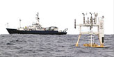
Stratus XVI
The sixteenth Stratus buoy was deployed at about 19°S, 85°W on May 13, 2017. It went adrift on 2018/01/04 at about 16:00 UTC, and was recovered on April 8, 2018.
Meteorology
 |
 |
Last updated: April 17, 2018.