

Project Stratus
| Location Map |
 |
| The Stratus project is located in the eastern tropical Pacific. |
| Surface Buoy |
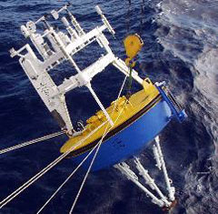 |
| The Stratus surface buoy being deployed. |
Overview
As part of the Eastern Pacific Investigation of Climate (EPIC) program, the UOP group has undertaken a study of Long-Term Evolution and Coupling of the Boundary layers in the Stratus Deck regions of the eastern tropical Pacific. The goal of the Stratus project is to observe and understand air-sea interactions and the surface forcing in the region of the cold tongue/intertropical convergence zone (ITCZ).
Beginning in October, 2000, we have maintained a fully-instrumented surface mooring at 22°S, 85°W to collect accurate time series of surface meteorology and upper ocean temperatures, velocities and salinities. The data collected will improve our understanding of the air-sea fluxes and sea-surface temperatures in the Eastern Tropical Pacific.
The Stratus mooring is an OceanSITES Ocean Reference Station, and is World Meteorologcal Organization station number 38400.
Signature of La Niña at Stratus Ocean Reference Station
The Stratus Ocean Reference Station is a well-instrumented surface mooring deployed in the eastern South Pacific off northern Chile. It was first deployed in October 2000 with support from NOAA, and it continues with planned annual service cruises with support from the Global Ocean Monitoring and Observing Program (GOMO) of NOAA. The ORS maintained by the WHOI Upper Ocean Processes Group take the approach of withholding observations in near-real time from assimilation by models in order to provide observations independent of models to support assessment of model realism and motivate improvements to the models. A recent paper (Weller et al., 2022) uses ORS observations to investigate the accuracy of surface fluxes of heat and momentum from modern atmospheric reanalyses (ERA5, NCEP2, and MERRA2) and CMIP6 coupled climate models.
Recently, the 22nd surface mooring deployed at the Stratus Ocean Reference Station (ORS) was recovered on March 13, 2025 from the Chilean research vessel Cabo de Hornos by a team from the Upper Ocean Processes Group of the Woods Hole Oceanographic Institution (WHOI) with Dr. Sebastien Bigorre as Chief Scientist. Ray Graham, Nico Llanos, and Nathan Smith rounded out the crew from WHOI. The 23rd surface mooring had been deployed on March 15, 2025. The Stratus ORS is located near 22.5°S, 85.8°W, off northern Chile. The Stratus ORS has provided unique long time series of surface meteorology, air-sea fluxes, and salinity, temperature, and velocity in the ocean since its first deployment in October 2000. The buoy carries a pCO2 system for NOAA PMEL and dissolved oxygen sensors for colleagues at GEOMAR in Kiel, Germany.
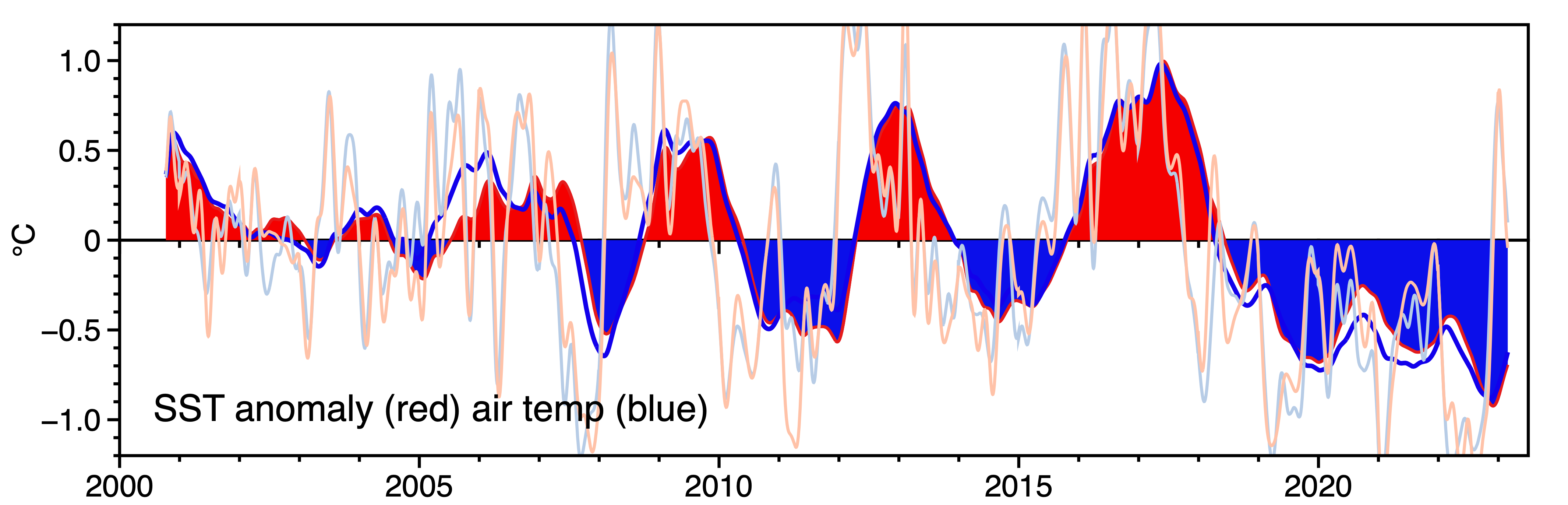
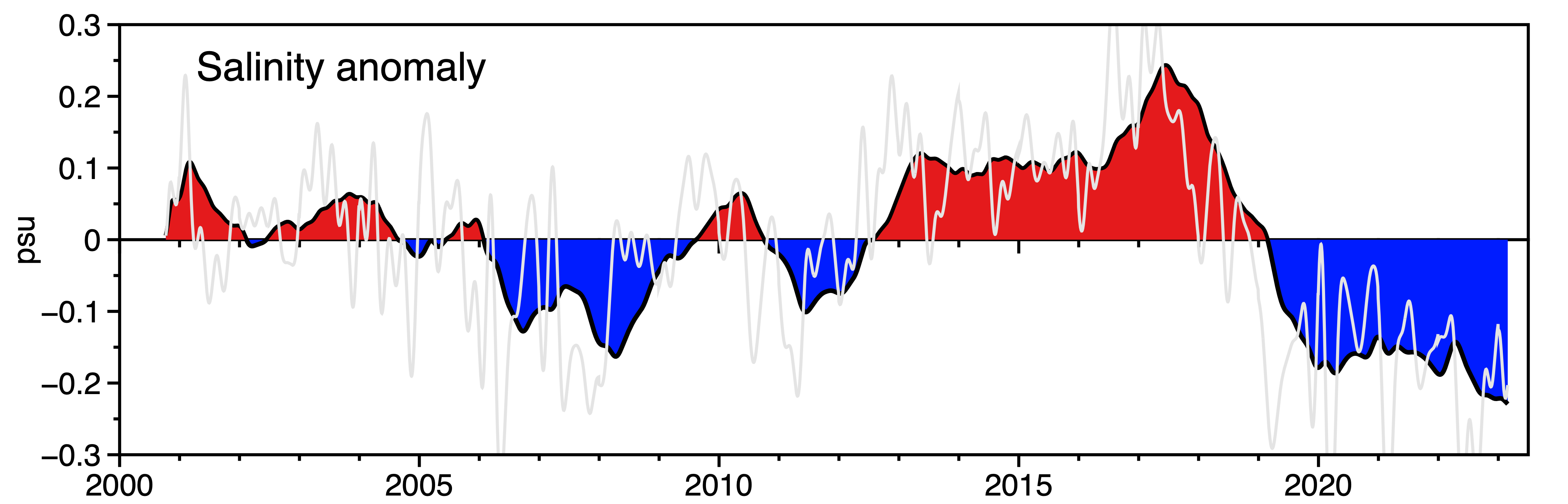
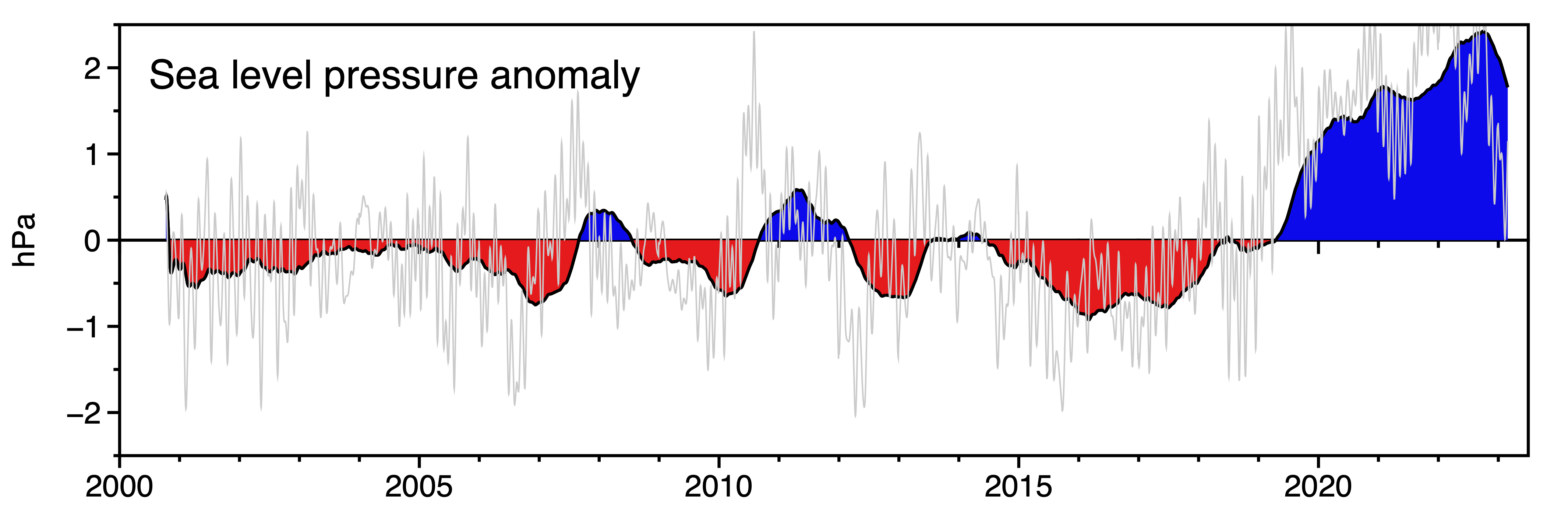
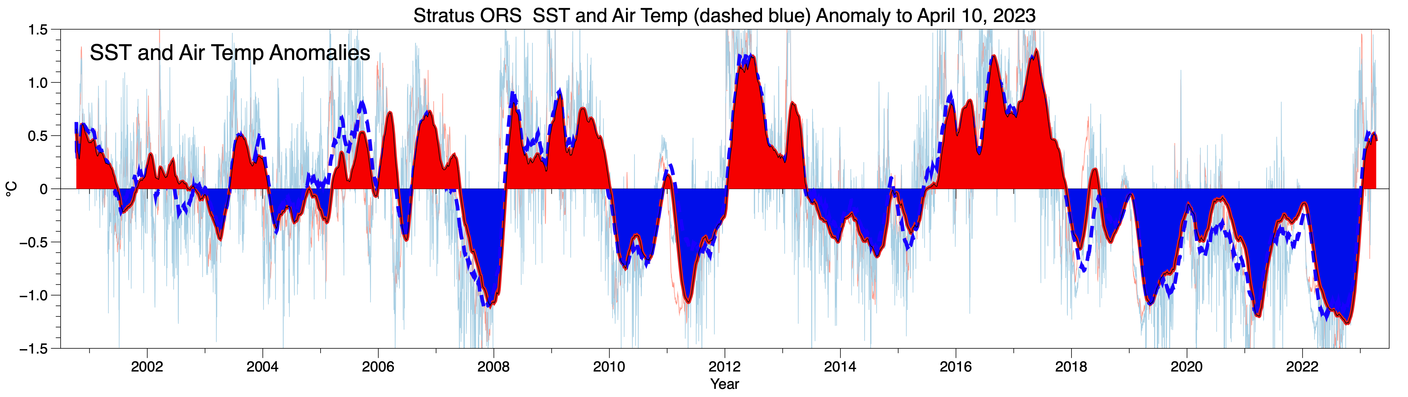
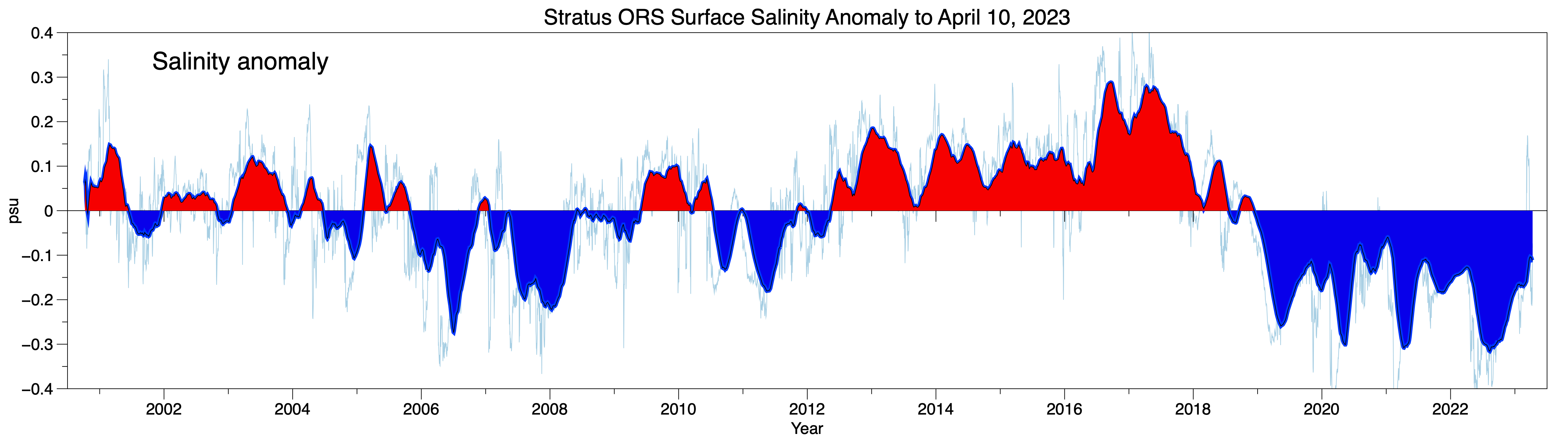
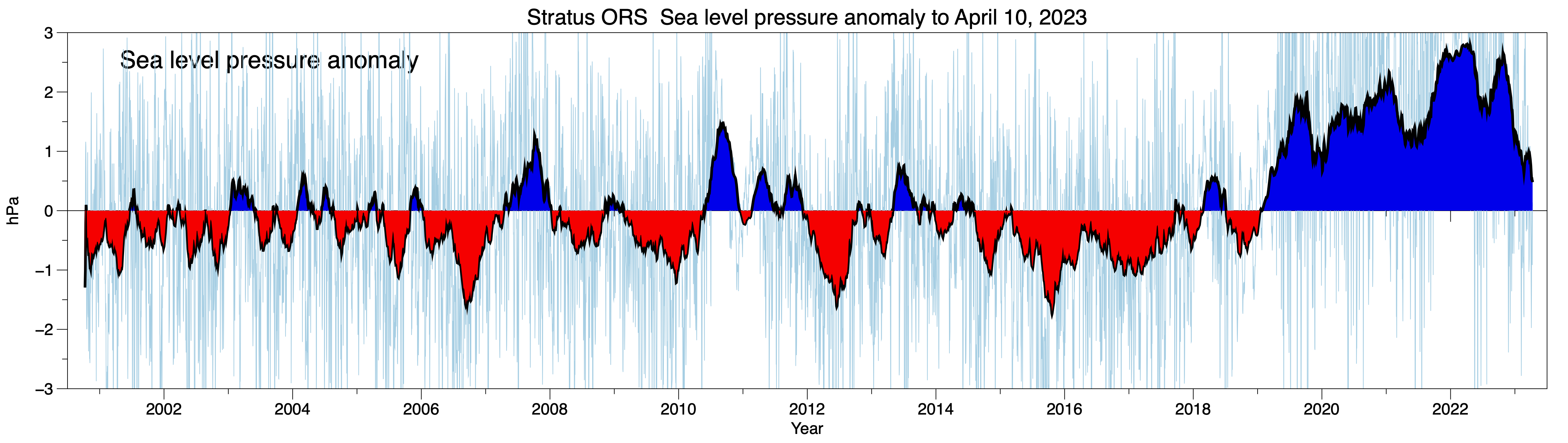
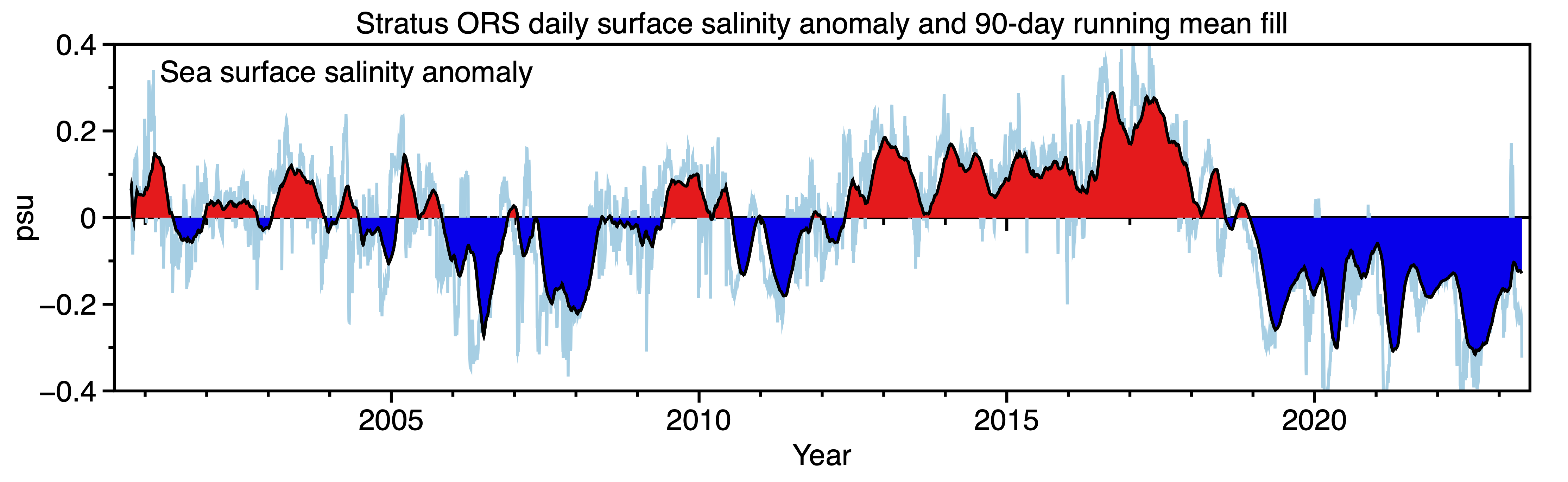
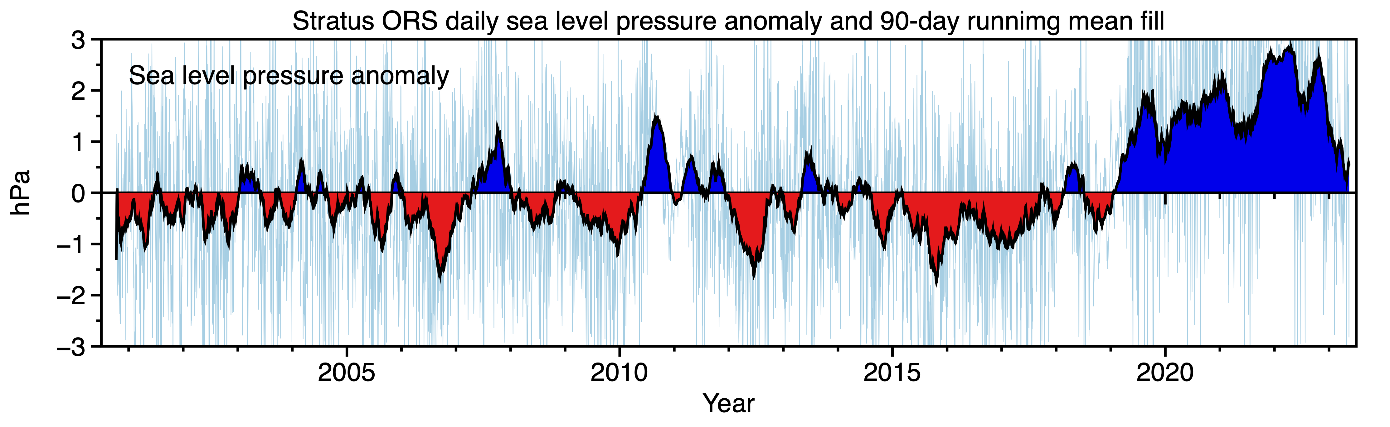
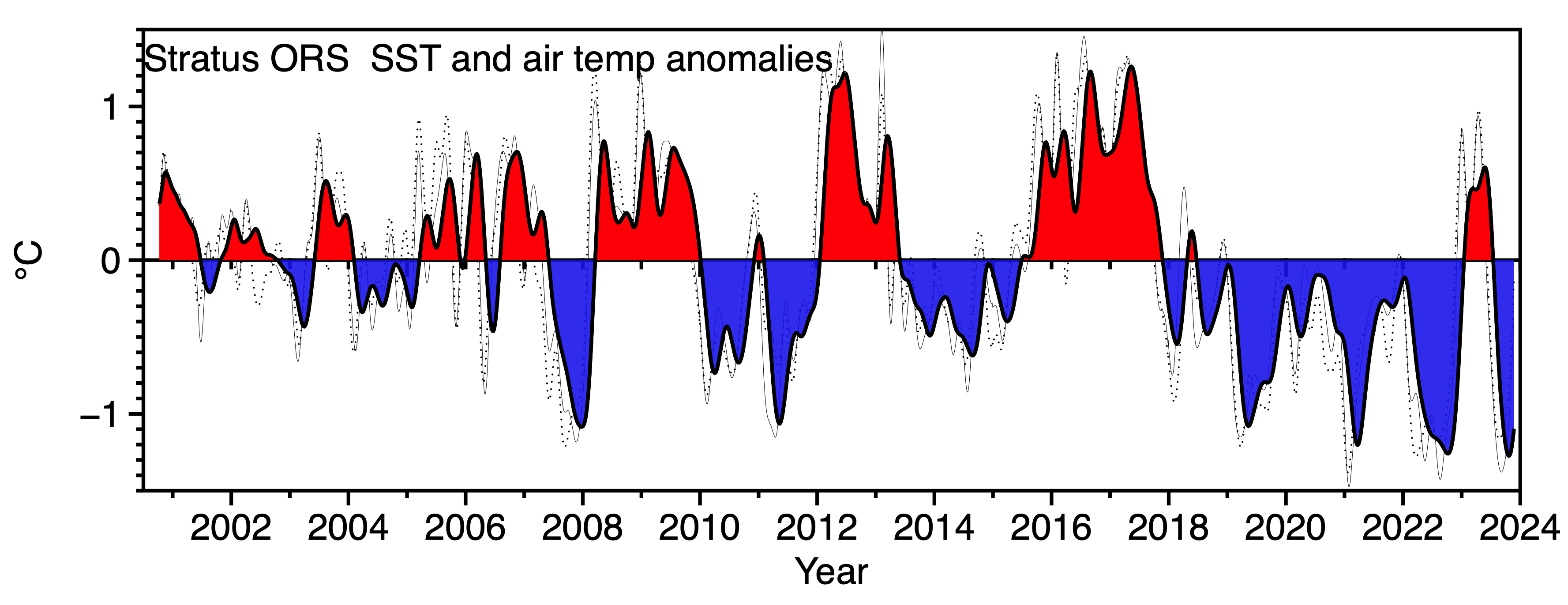
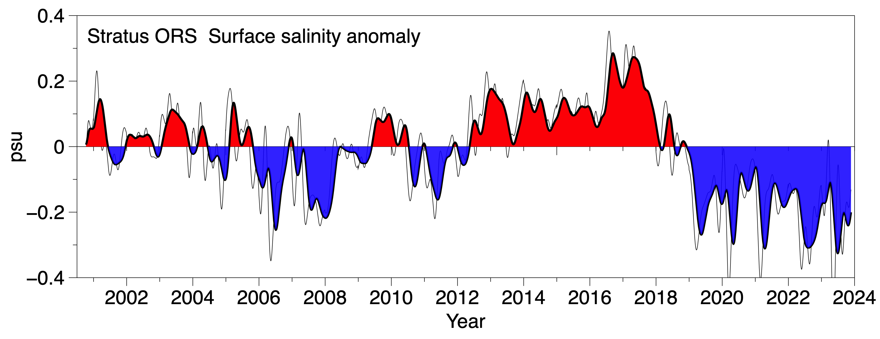
The cool ocean and air temperature signature of the recent prolonged La Niña has been apparent at the Stratus ORS. At the same time fresh salinity and an elevated sea level pressure anomalies have been observed. In the figures below a long-term mean annual cycle of daily-averaged values has been computed for each variable, and this has been subtracted to yield a daily record of anomalies from the mean annual cycle. The plots cover October 2000 to February 2023. Pale lines show the daily anomalies, while solid lines and the shading show 365-day smoothed time series. For more information please contact rweller@whoi.edu.
 |
 |
 |
Update to April 10, 2023
The temperature and sea level anomalies associated with the long La Niña are fading. The fresh salinity anomaly is persisting in this update using telemetered data from the Stratus OTRS.
 |
 |
 |
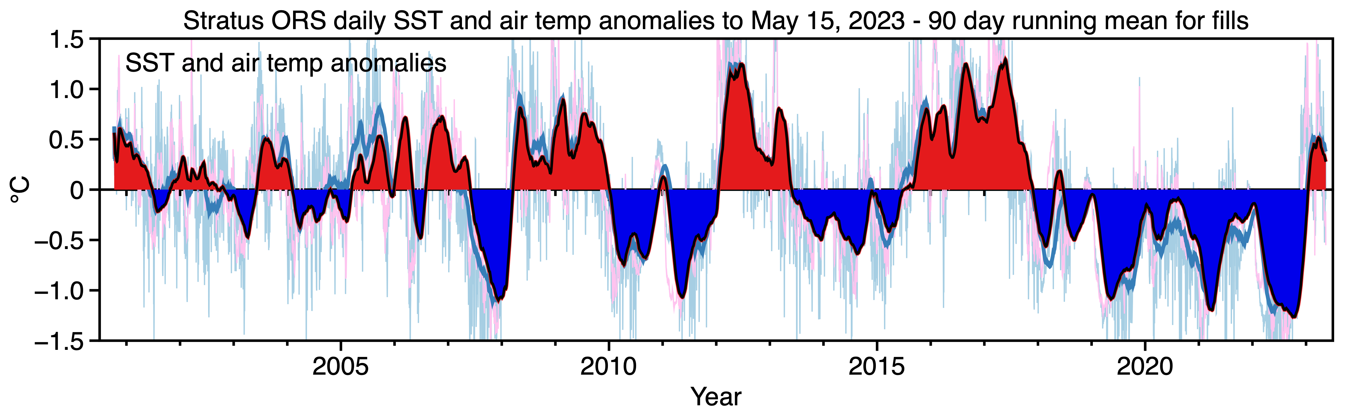
Update to May 15, 2023
Daily departures from the long-term mean annual cycle of daily values are shown as anomalies in pale time series. A 90-day running mean has been applied to these daily time series and those filtered time series are plotted with color fills. Telemetered updates from the Stratus 21 ORS deployment have been used to update the record to May 15. Data gaps have been filled using singular spectral analyses techniques.
As La Niña fades, low-passed SST and air temperature anomalies have gone positive, a fresh salinity anomaly persists, and the positive sea level pressure anomaly has decreased.
 |
 |
 |
Update to November 21, 2023
Telemetry of hourly surface meteorology and salinity/temperature from the sensors on the buoy bridle have been used to update the time series of low-passed anomalies at the Stratus ORS. These provide a look at how the region around the Stratus mooring is experiencing the La Niña to El Niño transition. A brief warm spike in anomalous temperature is coincident with a drop in anomalous sea level pressure (SLP) and in a short-lived decrease in the fresh salinity anomaly. Following this event, cool, fresh, elevated SLP conditions returned.
 |
 |
 |
Sponsors
The Stratus project project is supported by the National Oceanic and Atmospheric Administration (NOAA) Global Ocean Monitoring and Observing (GOMO) Program through the Cooperative Institute for the North Atlantic Region (CINAR) under Cooperative Agreement NA14OAR4320158. NOAA CPO FundRef number 100007298.
Last updated: 2025/04/01