
Contact us with questions at uop_dm@whoi.edu.
Project WHOTS - WHOI Hawaii Ocean Time-series Station
| Sponsors | ||
| ||

| More Details |
| WHOTS-I Mooring diagram Mooring log Hydrographic Observations at the WHOI-HOT Site (WHOTS): 2004 - 2006 |
| WHOTS-II Mooring diagram Mooring log Cruise report |
| WHOTS-III Mooring diagram Mooring log Cruise report |
| WHOTS-IV Mooring diagram Mooring log Cruise report |
| WHOTS-V Mooring diagram Mooring log Cruise report |
| WHOTS-VI Mooring diagram Mooring log Cruise report |
| WHOTS-VII Mooring diagram Mooring log Cruise report |
| WHOTS-VIII Mooring diagram Mooring log Cruise report |
| WHOTS-IX Mooring diagram Mooring log Cruise report |
| WHOTS-X Mooring diagram Mooring log Cruise report |
| WHOTS-XI Mooring diagram Mooring log Cruise report |
| WHOTS-XII Mooring diagram Mooring log |
| WHOTS-XIII Mooring diagram Mooring log |
| WHOTS-XIV Mooring diagram Mooring log |
| WHOTS-XV Mooring diagram Mooring log |
WHOTS-XVI Mooring diagram Mooring log |
| WHOTS-XVII Mooring diagram Mooring log Tower Diagram |
| WHOTS-XVIII Mooring diagram Mooring log |
| WHOTS-XIX Mooring diagram Mooring log |
| WHOTS-XX Mooring diagram Mooring log |
| WHOTS-XXI Mooring diagram Mooring log |
| Related Outside Links |
Research
The Hawaii Ocean Timeseries (HOT) site, 100 km north of Oahu, Hawaii, has been occupied since 1988 as a part of the World Ocean Circulation Experiment (WOCE) and the Joint Global Ocean Flux Study (JGOFS). WOCE investigators sought to document and understand seasonal and interannual variability of water masses, relate water mass variations to gyre fluctuations, and develop a climatology of high-frequency physical variability. JGOFS investigators sought to use information about primary production, new production, and particle export from the surface ocean as part of an interdisciplinary research program. The present HOT program includes comprehensive, interdisciplinary upper ocean observations, but does not include continuous surface forcing observations. Thus, the primary intent of the WHOTS mooring is to provide long-term, high-quality air-sea fluxes as a coordinated part of the HOT program and contribute to the goals of observing heat, fresh water and chemical fluxes at a site representative of the oligotrophic North Pacific Ocean.
Moorings
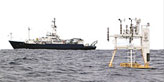
The surface mooring will be maintained for several years to obtain and examine in-situ records of surface meteorology, air-sea fluxes, and upper ocean variability. A Surlyn foam surface buoy is equipped with meteorological instrumentation including two complete Air-Sea Interaction Meteorological (ASIMET) systems, measuring air and sea surface temperatures, relative humidity, barometric pressure, wind speed and direction, incoming shortwave and longwave radiation, and precipitation. Complete surface meteorological time series is recorded every minute, as necessary to compute air-sea fluxes of heat, freshwater and momentum. Each ASIMET system also transmits hourly averages of the surface meteorological variables via the Argos satellite system.
The mooring line is instrumented in order to collect accurate time series of upper ocean temperatures, velocities, and salinities co-incident with the surface forcing record. Subsurface instrumentation is being supplied by the University of Hawaii. This includes vector measuring current meters, conductivity, salinity and temperature recorders, and an Acoustic Doppler current profiler (ADCP).
Field Work
Deployment times of the buoys:
| Deployment | Date | Water Depth (m) |
|---|---|---|
| 1 | 2004-08-13 | 4693 |
| 2 | 2005-07-28 | 4695 |
| 3 | 2006-06-27 | 4704 |
| 4 | 2007-06-26 | 4756 |
| 5 | 2008-06-05 | 4702 |
| 6 | 2009-07-11 | 4758 |
| 7 | 2010-07-29 | 4704 |
| 8 | 2011-07-07 | 4750 |
| 9 | 2012-06-14 | 4668 |
| 10 | 2013/07/11 | 4756 |
| 11 | 2014/07/17 | 4707 |
| 12 | 2015/07/12 | 4722 |
| 13 | 2016/06/27 | 4693 |
| 14 | 2017/07/28 | 4722 |
| 15 | 2018/09/23 | 4697 |
| 16 | 2019/10/06 | 4753 |
| 17 | 2021/08/26 | 4699 |
| 18 | 2022/07/24 | 4751 |
| 19 | 2023/06/17 | 4705 |
| 20 | 2024/06/02 | 4750 |
| 21 | 2025/09/24 | 4700 |
Last updated: 2026/02/17