
Project WHOTS - WHOI Hawaii Ocean Time-series Station
| Location Map |
 |
| WHOTS is at about 22° 45´ North, 158° West. |
| WHOTS Buoy |
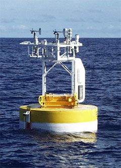 |
| The WHOTS surface mooring. |
Project WHOTS - WHOI Hawaii Ocean Time-series Station
Overview
In cooperation with the Hawaii Ocean Timeseries (HOT) project, the UOP Group has undertaken moored observations of surface forcing in the central Pacific. The primary intent of the WHOI HOT Station (WHOTS) is to provide long-term, high-quality air-sea fluxes as a coordinated part of the HOT program, and contribute to the HOT goals of observing heat, momentum, fresh water and chemical fluxes at a site representative of the oligotrophic North Pacific Ocean.
A moored surface buoy instrumented with a full complement of meteorological sensors was deployed in August, 2004 at about 22° 45´ North, 158° West. Subsurface instrumentation on the mooring is provided by the School of Ocean and Earth Science and Technology (SOEST), University of Hawaii under a grant from the National Science Foundation (NSF).
The WHOTS mooring site is an OceanSITES Ocean Reference Station, and is World Meteorologcal Organization station number 58400 (formerly 51400).
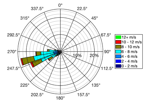
The means of the surface meteorological variables from the WHOTS ORES over 2004-2022 are summarized in this table.
| Sensor | Mean (2004-2022) | |
|---|---|---|
| Wind speed | m s-1 | 6.8 |
| Wind direction | ° | 264.0 |
| Sea temperature | °C | 25.2 |
| Air temperature | °C | 24.3 |
| Relative humidity | %RH | 75.6 |
| Sea level pressure | hPa | 1017.0 |
| Incoming solar | W m-2 | 238.1 |
| Incoming infrared | W m-2 | 388.8 |
| Rain rate | mm hr-1 | 0.06 |
Sponsors
The WHOTS project is supported in part by the National Oceanic and Atmospheric Administration (NOAA) Global Ocean Monitoring and Observing (GOMO) Program through the Cooperative Institute for the North Atlantic Region (CINAR) under Cooperative Agreement NA14OAR4320158. NOAA CPO FundRef number 100007298. Additional support is provided by the National Science Foundation, Division of Ocean Sciences.
Last updated: 2026/06/25