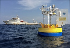
Bay of Bengal
Monsoon Buoy
 |
| Principal funding provided by Office Of Naval Research |
| See also |
| Readme file |
Atmospheric Forcing and the Structure and Evolution of the Upper Ocean in the Bay of Bengal
Data Access- Shared quality-controlled surface meteorology and air-sea fluxes
We are providing for all to use the surface meteorological and air-sea flux time series collected on the WHOI surface mooring at 18°N, 89.5°E deployed by Drs. Tom Farrar and Robert Weller with support from the U.S. Navy Office of Naval Research (ONSR).
Please acknowledge the source of the data; acknowledgement details are included in the
Readme file. The reference that should cited in conjunction with the use of the surface
meteorological and air-sea flux data from the WHOI buoy is:
Weller, R.A., J.T. Farrar, J. Buckley, S. Mathew, R. Venkatesan, J. Sree Lekha, D. Chaudhuri, N. Suresh Kumar,
and B. Praveen Kumar. 2016. Air-sea interaction in the Bay of Bengal. Oceanography 29(2):28–37, http://dx.doi.org/10.5670/oceanog.2016.36
We have used redundant data from the buoy and other information to produce a single set of time series of surface meteorology and of the air-sea fluxes of heat, freshwater, and momentum. Both are provided at different sampling rates: one-minute, one-hour, one-day, and one-month. Because we need to compute wind velocity relative to surface current, we also include the 2 meter deep ocean velocity time series we used in the flux computation.
Met data
| Record Rate | NetCDF | ASCII, g'zipped | Metadata | Quick Plot | Matlab File |
|---|---|---|---|---|---|
| 1 minute | Bengal_1_D_M-60s | Bengal_1_D_M-60s | Bengal_1_D_M-60s | Bengal_1_D_M-60s | beng1_met_60s |
| 1 hour | Bengal_1_D_M-1hr | Bengal_1_D_M-1hr | Bengal_1_D_M-1hr | Bengal_1_D_M-1hr | beng1_met_1hr |
| 1 day | Bengal_1_D_M-1d | Bengal_1_D_M-1d | Bengal_1_D_M-1d | Bengal_1_D_M-1d | beng1_met_1d |
| 1 month | Bengal_1_D_M-1mnth | Bengal_1_D_M-1mnth | Bengal_1_D_M-1mnth | Bengal_1_D_M-1mnth | beng1_met_1mnth |
Surface Flux Data
| Record Rate | NetCDF | ASCII, g'zipped | Metadata | Quick Plot | Matlab File |
|---|---|---|---|---|---|
| 1 minute | Bengal_1_D_F-60s | Bengal_1_D_F-60s | Bengal_1_D_F-60s | Bengal_1_D_F-60s | beng1_flux_60s |
| 1 hour | Bengal_1_D_F-1hr | Bengal_1_D_F-1hr | Bengal_1_D_F-1hr | Bengal_1_D_F-1hr | beng1_flux_1hr |
| 1 day | Bengal_1_D_F-1d | Bengal_1_D_F-1d | Bengal_1_D_F-1d | Bengal_1_D_F-1d | beng1_flux_1d |
| 1 month | Bengal_1_D_F-1mnth | Bengal_1_D_F-1mnth | Bengal_1_D_F-1mnth | Bengal_1_D_F-1mnth | beng1_flux_1mnth |
Surface Currents Data
| Record Rate | NetCDF | ASCII, g'zipped | Metadata | Quick Plot | Matlab File | |
|---|---|---|---|---|---|---|
| SurfVel | 1 hour | Bengal_1_D_surfV | Bengal_1_D_surfV | Bengal_1_D_surfV | Bengal_1_D_surfV | nortek_2mbin_4flux |
Page updated: May 17, 2016


