Bay of Bengal
Monsoon Buoy
 |
| Principal funding provided by Office Of Naval Research |
| Partners |
| Indian National Centre for Ocean Information Services |
| Nationl Institute of Ocean Technology |
Atmospheric Forcing and the Structure and Evolution of the Upper Ocean
in the Bay of Bengal
Introduction
The focus of this project is an investigation of the processes that determine the vertical structure and evolution of the upper ocean in the southern Bay of Bengal. Our long-term goals are to improve understanding and simulation of physical processes in the upper ocean that influence air-sea interaction and the upper-ocean environment.
The Bay of Bengal is an interesting region from the perspective of air-sea interaction: the presence of a salinity-stratified barrier layer is believed to have important effects on the SST field and the regional atmosphere because the shallow stratification favors a relatively rapid response of the upper ocean to surface forcing. The strong, shallow stratification in the region and the dynamical processes governing the upper-ocean structure and air-sea interaction have not yet been adequately characterized and understood, posing a challenge to the ability of numerical models to simulate and predict changes in the ocean and atmosphere there. With this project, we seek to use new and existing measurements to test, scrutinize, and improve the conceptual, theoretical, and dynamical constructs of air-sea interaction in the Bay of Bengal.
Approach
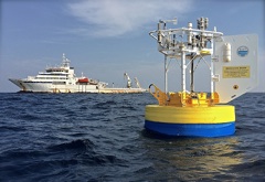
Our initial work involved deploying our Underway CTD (UCTD) on cruises in Bay of Bengal in support of the collaborative research effort. Our main effort was deployment of a well- instrumented surface mooring well-instrumented, air-sea interaction mooring near 18°N, 89°E to collect measurements of the air-sea exchange of heat, momentum, and freshwater and the coincident evolution of the upper ocean. Closely-spaced temperature and salinity sensors in the upper 200m along with velocity sensors will allow us to examine the variability and dynamics of the upper layer where precipitation and river runoff contribute to salinity stratification. The deployment was done in December 2014 from R.V. Sagar Nidhi. This mooring was recovered in January 2016 from R.V. Sagar Kanya.
During the deployment we telemetered the hourly surface meteorology and computed the hourly air-sea fluxes of heat, freshwater, and momentum using the COARE bulk formulae. The real-time surface meteorology and the fluxes computed from the telemetered meteorology were shown and available on this website (Real-time Data, Surface Fluxes).
When the mooring was recovered, the raw data files were obtained from the instruments on the surface buoy as well as from the instruments attached to the mooring line. Our immediate goal upon obtaining these data files was to go ahead with quality-control and processing of the surface meteorological data, correcting any biases or drifts and using the redundant observations to make one ?best? one-minute time series of surface meteorology. This was used to make one-hour, one-day, and one-month time series of surface meteorology. We then used 2 m deep currents to compute wind velocity relative to the surface current and the COARE bulk formulae and related bulk formulae to compute the air-sea fluxes of heat, freshwater, and momentum. Note that our convention is for the time word (UTC) to be associated with the middle of the sample interval.
We are sharing the four surface meteorological files (one-minute, one-hour, one-day, and one-month), four air-sea flux files (one-minute, one-hour, one-day, and one-month), and the 2m deep ocean velocity file we used to compute wind velocity relative to the current.
We acknowledge the support of the U.S. Navy Office of Naval Research and ask that users of the data from the surface mooring acknowledge the source of the data.
Partners
Principal research collaborators are Dr. Debasis Sengupta, Center for Atmospheric and Oceanic Sciences, Indian Institute of Science, Dr. M. Ravichandran, Indian National Centre for Ocean Information Services (INCOIS), and Dr. R. Venkatsen, Nationl Institute of Ocean Technology. We also worked with Emily Shroyer and Jim Moum of Oregon State University, who deployed a number of their turbulence sensors. We are grateful for the efforts of all on board R.V. Sagar Nidhi and R.V. Sagar Kanya who made the deployment and recovery or the mooring possible.
Page updated: November 4, 2016


