
Completed Project: Pan-American Climate Study (PACS)
Principal Investigators
Robert Weller, and Steven P. AndersonDepartment of Physical Oceanography
Woods Hole Oceanographic Institution
Woods Hole, MA
Summary
The Pan American Climate Study (PACS) is a broad collaboration of oceanographers and meteorologists who seek to improve understanding of the processes that couple the ocean and atmosphere with a goal of improving the skill of operational seasonal-to-interannual climate prediction. The sea surface temperature field in the eastern tropical Pacific, with its strong asymmetry about the equator and annual and interannual variability, and links between the sea surface temperature field and climate are of great interest to PACS. However, our understanding of the processes that control sea surface temperature there is lacking. Uncertainties in existing climatologies of the surface heat flux, wind stress, and precipitation are large. The ITCZ and the warm water north of the equator both move north and south annually, but the details of the coupling between the two are unknown.
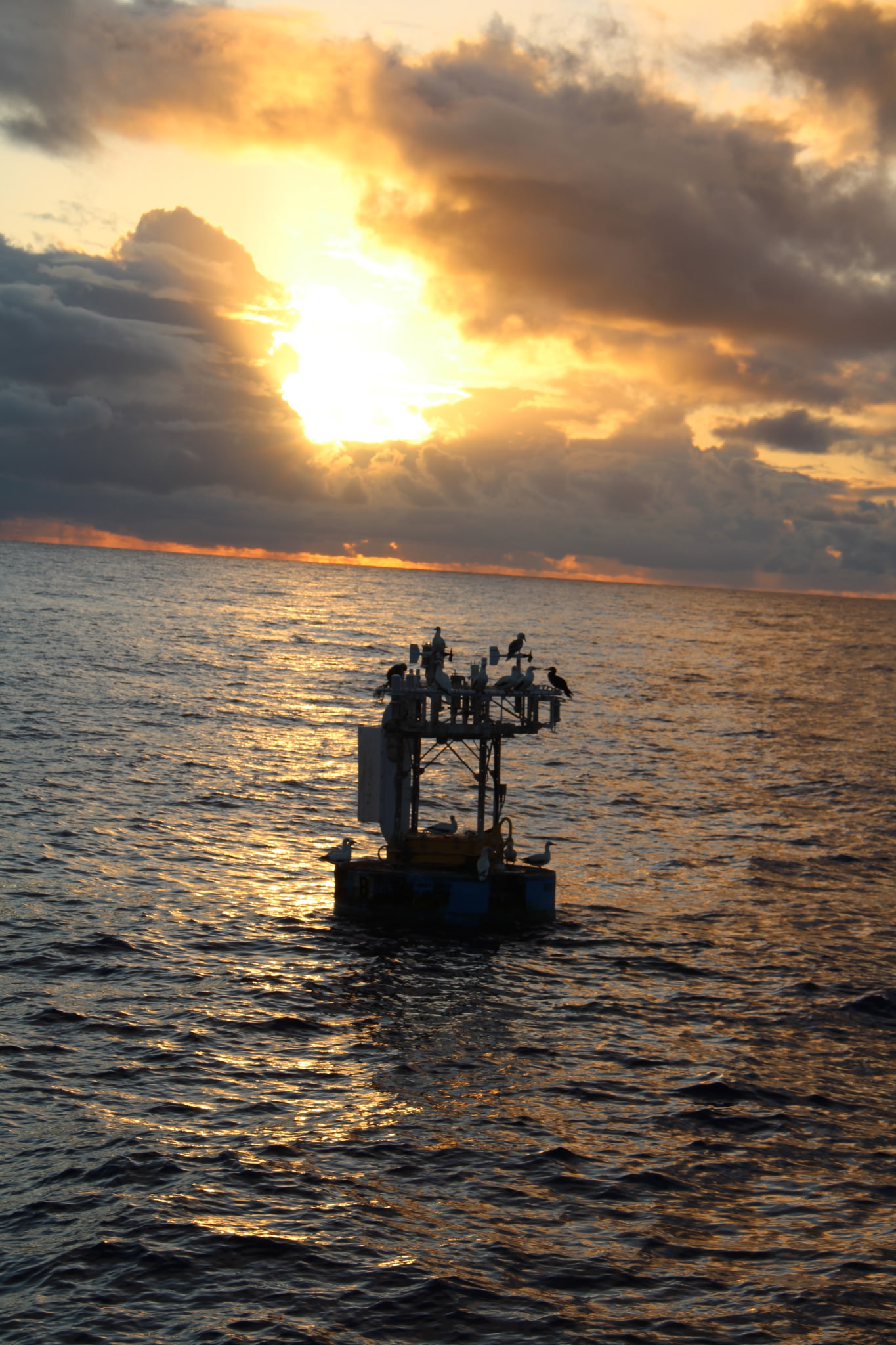
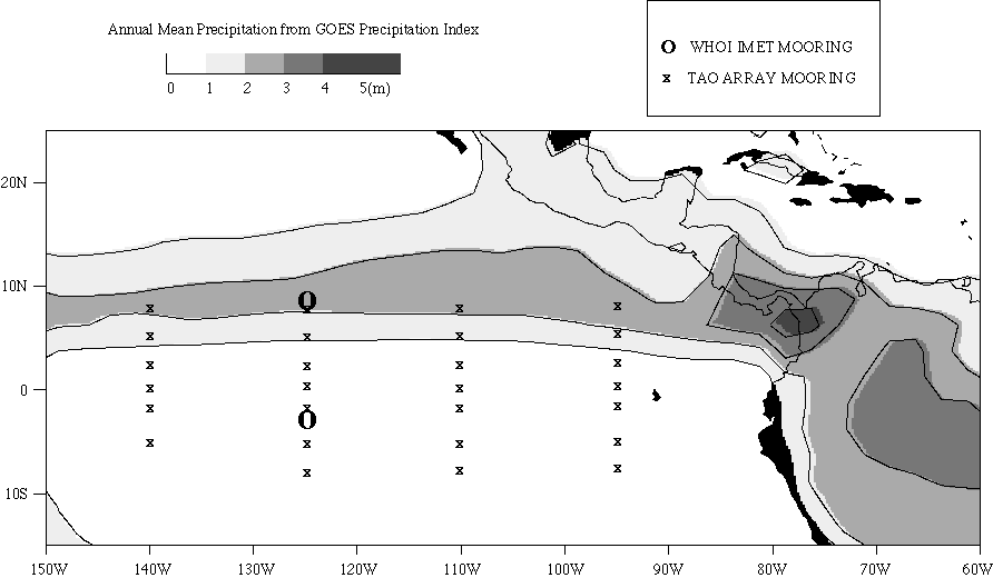
From May 1997 to September 1998, in a study for PACS, sites at 3 S and 10 N along 125 W were occupied with moorings equipped to collect accurate time series of surface meteorology and upper ocean temperatures, velocities, and salinities. The two sites span strong gradients in ocean temperature, from the northern side of the cold tongue to the warm water found north of the equator, and cloud cover and precipitation, from south of the ITCZ to under the ITCZ (fig. 1).
Although the mooring program was designed to study the seasonal cycle, one of the largest El Nino events on record occurred while the moorings were deployed. So, the data from heavily instrumented moorings provide a unique opportunity to gain insight into the processes that were important in determining sea surface temperature during the large El Nino event and the abrupt transition of the tropical Pacific to a La Nina state. Data from the moorings will improve our understanding of the air-sea fluxes in the eastern tropical Pacific and be used to examine the processes that control sea surface temperature there. In collaborative work the accurate fluxes and sea surface temperature data will support examination of climatologies and of the performance of ocean and coupled models in this region. It is anticipated that the improved air-sea fluxes and understanding of local atmosphere-ocean coupling will also motivate further studies into the role of meridional sea surface temperature gradients in driving the atmosphere and into the interaction of the surface temperature field and the location and strength of the ITCZ.
Measurement Program
Seventeen month time series of the air-sea fluxes and upper ocean variability have been collected at two locations located along the 125W longitude line in the eastern tropical Pacific. Surface moorings provide the means of collecting the necessary data. The technology being used was highly successful in the recent TOGA COARE, Arabian Sea and Coastal Mixing and Optics Experiement.Measurements began in April 1997 when two WHOI surface moorings were deployed at 3 S and 10 N on 125 W. After 8 months, the moorings were recovered and redeployed (December 1997). The moored instrumentation has a proven useful life of 6 to 8 months. At longer deployments, questions arise about biofouling of the oceanographic instruments and calibration drift in the meteorological sensors on the buoy. The WHOI moorings were recovered in September 1998.
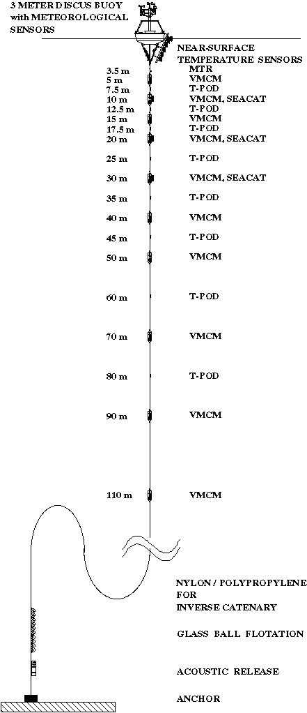
The WHOI moorings were equipped with two complete sets of meteorological sensors (wind velocity, air and sea temperature, incoming shortwave and incoming longwave radiation, relative humidity, barometric pressure, precipitation, surface currents), using redundancy to ensure that complete time series of all variables were collected, thus permitting calculation of the heat, mass, and momentum fluxes via the bulk formulae (fig. 2). Meteorological data from both buoys is telemetered via Service Argos and monitored at WHOI as well as made available to other investigators. The WHOI buoys are fitted with a closely spaced array of temperature recorders to resolve diurnal heating near the sea surface (depths of 0.05, 0.45, 1.0, 1.5, 2.0, and 2.5 m) and a floating surface temperature sensor to record sea surface temperature as close to the surface as possible, with four Seacat conductivity/temperature recorders (at 1, 10, 20, 30 m), and ten Vector Measuring Current Meters (at 5, 10, 15, 20, 30, 40, 50, 70, 90, 110 m) which measure horizontal velocity and temperature, and 9 Brancker temperature recorders (at 7.5, 12.5, 17.5, 25, 35, 45, 60, 80, and 150 m) which record temperature. Temperature on all instruments is accurate to approximately 0.010 DegC.
Meteorological and oceanographic data are sampled once per 7.5 minutes. The focus in this study is largely on surface temperature and the upper ocean response to local atmospheric forcing. The ocean temperature array is designed to track the mixed layer depth and fully resolve the temperature structure near the surface. The salinity sensors are located where they can be used to identify rainwater freshening as well as advective change in water properties. The ten current meters are located where they will provide a record of the near-surface shear and flow within the mixed layer.
At the times of deployment and recovery, the ship sits close by the buoys for 24 hours, making measurements of surface meteorology, sea surface temperature, and upper ocean temperature, salinity and velocity. We bring on these cruises meteorological sensors good enough to serve as calibration transfer standards. Air temperature measurements, for example, is being made with an aspirated sensor. Such intercomparisons, along with careful pre- and post-deployment calibrations, were found during TOGA COARE to provide the means to greatly improve the accuracy achieved by the moored instrumentation.
The bulk formulae being used to calculate the fluxes is the latest version of the TOGA COARE bulk formulae which was refined by comparing direct (eddy covariance) and bulk formulae fluxes during COARE. The parameterizations were found to work well in low wind, equatorial conditions but have also been verified against other data sets that include higher wind speeds than observed during COARE. We will encourage other investigators to propose efforts to profile the optical properties (absorption, fluorescence) during these intercomparisons to assist in determination of the optical extinction coefficients appropriate to this area.
Figure Captions
Figure 1. Map of WHOI IMET PACS and TAO mooring locations in the eastern tropical Pacific Ocean. Overlaid is the annual mean precipitation from the GOES precipitation index. The two IMET mooring sites span the strong gradients cloud cover and precipitation, from south of the ITCZ to under the ITCZ.
Figure 2. Mooring diagram showing location of subsurface instrumentation on the WHOI IMET PACS moorings.
Other PACS links:
Pan American Climate Studies (PACS)
PACS Data Management Center
Tropical Eastern Pacific Process Study Cruise
Last updated: April 11, 2008